El proyecto ES_Bioeconomía continuó realizando acciones durante el mes de febrero pasado

El proyecto ESBioeconomía sigue con sus acciones ligadas a la formación, fomento y difusión de la Economía Social en Bioeconomía. Los ejes de este proyecto son tres: emprendimiento, innovación y liderazgo femenino. Las acciones llevadas a cabo durante el pasado mes de febrero han sido:

En la ETSI Montes, Forestal y del Medio Natural de la UPM

El 6 de febrero, nuestro compañero Pablo Ascasibar, socio de AGRESTA S. Coop., presentó el proyecto en Escuela Técnica Superior de Ingenieros de Montes, Forestal y del Medio Natural de la Universidad Politécnica de Madrid  dentro del marco de las acciones formativas que esta Universidad ejecuta en colaboración con el programa europeo Green at You.

La ponencia tuvo como título: «Emprendimiento cooperativo para la Bioeconomía forestal».

En el Urban Forest Innovation Lab de Cuenca

Urban Forest Innovation Lab (UFIL) es un programa para el emprendimiento en bioeconomía forestal de Cuenca. Combina aprendizaje basado en proyectos, tutorización, incubación y aceleración de ideas innovadoras en torno a la bioeconomía forestal.

Pilar Durante y José Luis Tomé, ambos socios de AGRESTA S. Coop., participaron en la Mesa Redonda Innovación y Bioeconomía Forestal de UFIL, presentando la línea de innovación del proyecto  ES_Bioeconomia. El acto tuvo lugar el viernes 7 de febrero.

En centros formativos de la provincia de Valencia

Tuvimos ocasión de presentar acciones ligadas al proyecto, relacionadas con emprendimiento juvenil, en dos centros formativos de Valencia:

  • CIP de Formación Profesional Complejo Educativo Cheste, en dos ciclos: Educación y Control Ambiental y Gestión Forestal y del Medio Natural
  • IES Alto Turia (Chelva): con alumnado del Ciclo Medio Aprovechamiento y Conservación del Medio Natural y del Ciclo Superior Gestión Forestal y del Medio Natural

Día de la Mujer y la Niña en la Ciencia 

Con motivo del Día de la Mujer y la Niña en la Ciencia (11 de febrero) organizamos una sesión online titulada «Dando voz: Pregunta a una científica». Este evento no solo buscaba visibilizar el trabajo de mujeres en áreas STEM, sino también romper barreras y, por qué no, tender puentes entre disciplinas aparentemente distantes, como la ciencia y el arte.

Esta acción estuvo enmarcada dentro del proyecto ES_Bioeconomía en relación con el eje de liderazgo femenino.

Con alumnado de Ciclo Superior del Centro Integrado de Formación Profesional de Coca (Segovia)

Nuestros compañeros Pablo Ascasibar y David Lasala se desplazaron el pasado 13 de febrero a Coca, para impartir una charla en relación al eje 1 del proyecto (Fomentar el emprendimiento juvenil y el relevo generacional).

En el IES El Carmen de Cazalla de la Sierra (Sevilla)

Ángel Lobo, socio de AGRESTA S. Coop., miembro de nuestra sede en Sevilla, tuvo ocasión de compartir nuestra experiencia cooperativa dentro del sector forestal con alumnado del IES El Carmen de Cazalla de la Sierra, en Sevilla, que cuenta con ciclos formativos agroforestales.

En el Urban Forest Innovation Lab de Cuenca

El viernes 21 de febrero, volvimos a participar en el Urban Forest Innovation Lab (UFIL) en Cuenca. Esta vez pudimos compartir la línea de emprendimiento del proyecto ES_Bioeconomia: validación económico-financiera y la creación de empresas de impacto.

Participación en el seminario «Biomasa forestal en Andalucía»

En relación al eje 3 del proyecto (Mejorar la capacitación e innovación técnica y organizacional), José Luis Tomé, responsable de I+D en AGRESTA, tuvo ocasión de participar en el seminario online BIO+A Málaga «Biomasa forestal en Andalucía» que tuvo lugar el 25 de febrero. En este evento pudo exponer nuestra experiencia en innovación, con casos concretos ligados a biomasa forestal.


El proyecto ES_BIOECONOMÍA figura dentro la resolución definitiva de la Dirección General de la Economía Social y de la Responsabilidad Social de las Empresas para la concesión de ayudas en régimen de concurrencia competitiva en la convocatoria 2024-2025 del Plan Integral de Impulso a la Economía Social para la Generación de un Tejido Económico, Inclusivo y Sostenible, en el marco del Plan de Recuperación, Transformación y Resiliencia.

ES_BIOECONOMíA es un programa itinerario de formación, fomento y difusión de la Economía Social en Bioeconomía, para el emprendimiento juvenil, relevo generacional y liderazgo femenino. Así, para abordarlo se han establecido los objetivos específicos:

Fomentar el emprendimiento juvenil y el relevo generacional
Impulsar el liderazgo femenino y su visibilidad
Mejorar la capacitación e innovación técnica y organizacional


Detektia releases EyeRADAR Android APP: An all in one structural health monitoring mobile application

Detektia is a startup specialized in infrastructure monitoring from space. They bring satellite data to decision-making in the infrastructure sector. Agresta has been collaborating with them since their begining in 2019.

Detektia remotely measures millimetric deformations of infrastructures and land surfaces. They do not use any type of ground devices, Detektia achieves this by using radar satellite sensors.

If you would like to know more details about how Detektia is able to transform satellite information into early infrastructure deformation warnings, please continue reading.

If you go on reading you will also learn why is so important remote sensing technology in infrastructure monitoring, some interesting details about EyeRADAR, Detektia’s infrastructure management software and a glimpse of the mobile APP that Agresta has developed using its API.

The importance of remote sensing in structural health monitoring (SHM)

Accidents such as the one that occurred in the city of Genoa (Italy) in 2018 where the Morandi Bridge collapsed let us know the importance of infrastrucure monitoring. 43 people died in Morandi Bridge. In 1959, a dam failed in Malpasset (France) where more than 400 people died.

The main aim of structural health monitoring is the follow-up and inspection of infrastructures. SHM provides kind of x-ray of a infrastructure. The data taken from infrastructures allow Detektia detecting any risk and/or deterioration in it.

The generation of early warnings is not limited to the prevention of accidents such as those already mentioned. It also allows detecting any anomalous behavior in advance, for example to reduce maintenance costs and plan the actions to be carried out with enough time.

shm eyeradar detektia

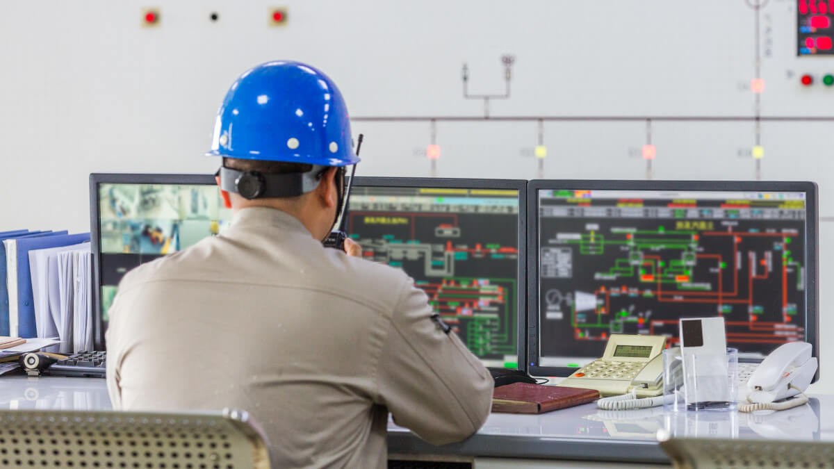
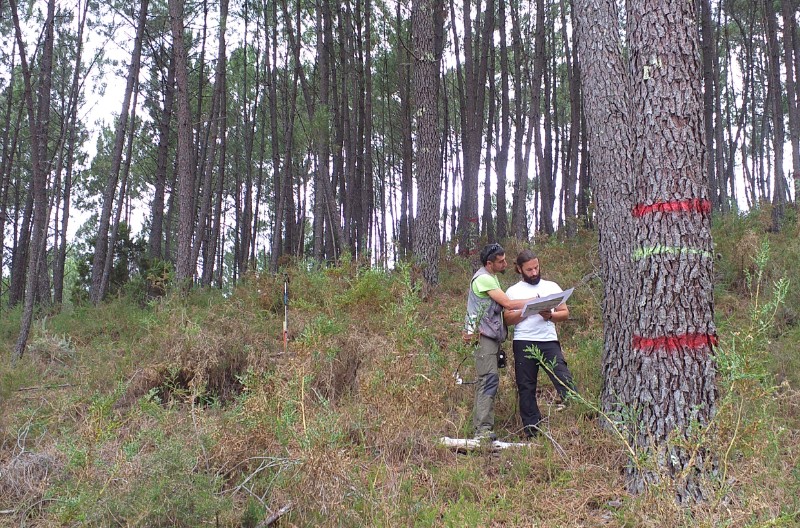
Ideally, every infrastructure should be monitored in real time. This would make it possible to detect any anomaly on it. The monitoring and auscultation of infrastructures has historically been carried out through the use of ground devices.

Although the data provided by ground devices is highly accurate, there are some important limitations: On the one hand, an installation process is required which is usually quite costly. Reparation and disassembly tasks are also required. In addition, an infrastructure usually requires high number of sensor devices which increases the cost.

On the other hand, the energy available in sensors is usually limited. As a result, the transfer of information and/or communication must be relatively low in order to extend their useful life.

One of the most important features in structural health monitoring is to have real-time information. However, limiting the frequency of data transfer from devices takes us away from this scenario.

Technological improvements of remote sensing and the high availability of satellite images, have completely changed the infrastructure monitoring business. Detektia, undoubtedly belongs to the group of companies that are revolutionizing SHM sector.

The use of DinSAR satellite technology allows Detektia to carry out continuous measurement of millimeter deformations and consequently, the generation of structural health metrics and early warnings.

Candela Sancho, CEO of DetektiaCandela Sancho – CEO of Detektia
“Our solution helps creating safer and more efficient infrastructures with significant cost savings, reduced carbon footprint and avoid disasters.”

Thanks to the technology developed by Detektia, infrastructure managers can make better decisions during the planning, design or execution of a project.

The main advantage of DinSAR technology for infrastructures monitoring in compisson with ground-based instrumentation is the possibility of monitoring large areas and creating huge volumes of control points without necessarily implying a higher cost.

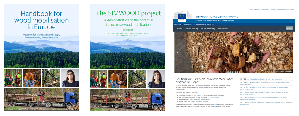
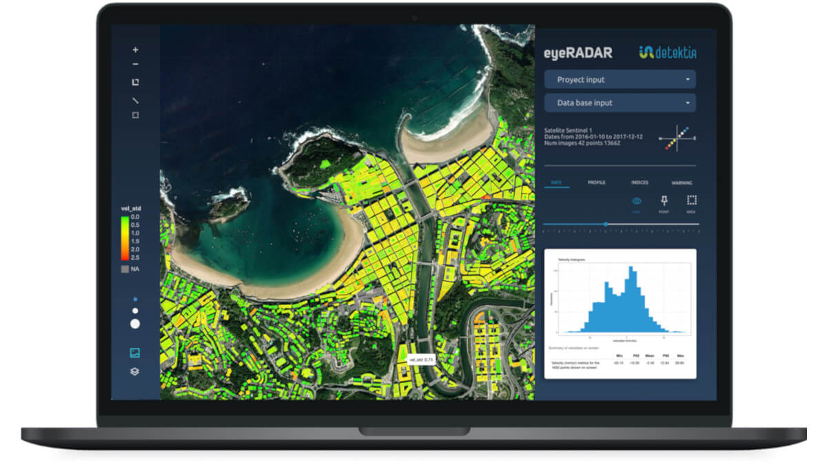
EyeRADAR, the ultimate all in one SAAS for infrastructures deformation monitoring

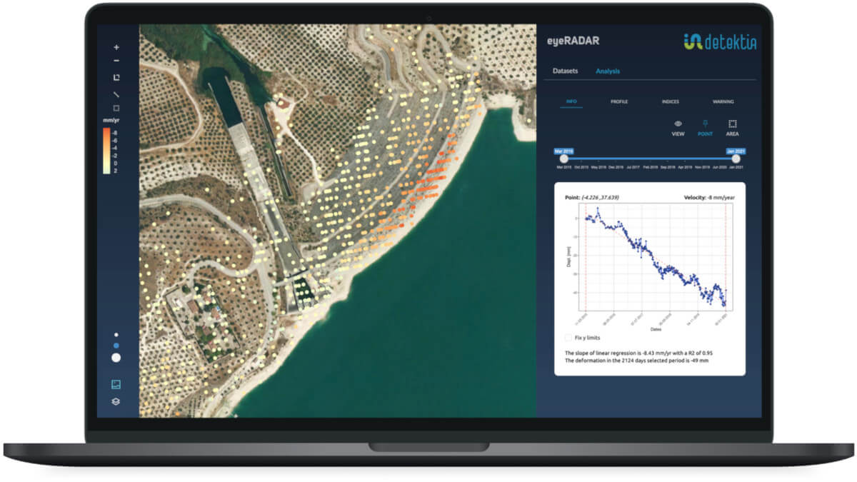
Detektia has developed EyeRADAR web platform which allows users to analyze deformation series, indices and metrics in a very visual and interactive way.

EyeRADAR automatically generates alerts and warnings when custom metrics exceeds specific thresholds. Thanks to this feature, infrastructures managers don’t have to be aware of analyzing the deformation at every update; EyeRADAR alerts them when something anomalous is happening. The alerts and metrics are based on AI models. They help to get a real interpretation of the enormous volume of information generated by satellite radar technology.

EyeRADAR is a software as a service tool (SaaS) that could be easily used in any device without installation, it automatically provides software updates as well as faster and efficient support.

EyeRADAR provides a custom module that lets users integrating it not only with DInSAR data sources. It is compatible with other data sources such as data taken from ground devices (piezometers, accelerometers, inclinometers…) or topography campaigns (leveling, total station, GNSS…) etc.

Would you like to know more about EyeRADAR? Have a look to its website! A free trial is available.

EyeRADAR API: integration with third-party platforms

An API (Application Programming Interfaces) is a software that makes it possible the communication between two or more applications. The API of EyeRADAR lets using your preferal infrastructure management software by taking advantage of every feature provided by EyeRADAR online tool.

That is, by using the API of EyeRADAR you could integrate or connect it with your custom infrastructure software.

EyeRADAR API of Detektia

Detektia has dedicated a huge effort during 2022 to develope their API. Detektia has been working with Victor Olaya during this process. Victor is a forestry engineer and an important figure thanks to its essential book on Geographic Information Systems. Victor has been working with Detektia on the development of a QGiS plugin for visualization and analysis of DInSAR time series for Detektia.

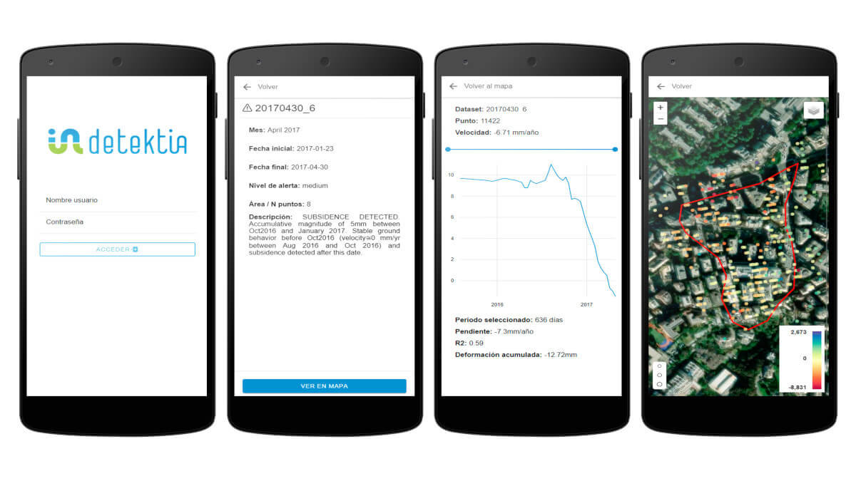
Agresta’s has been testing the EyeRADAR API in order to develop a new mobile application which is actually available for Android devices. It lets users accessing to deformation alerts, know the details of them, locate them on the map and analyze the time series of deformations.

Aplicación móvil para dispositivos con sistema operativo con API EyeRADAR

Once the development is finished, we could conclude that the API is very well documented. Thanks to documentation provided by Detektia the integration of EyeRADAR features into other application becomes a really simple task.

A step forward in infrastructure monitoring

The integration of deformation data taken from satellite radar in mobile devices is without any doubts a big improvement in infrastructure monitoring: Infrastructure inspectors could receive notifications on their mobile devices containing deformation alerts. The responsible technicians can review this alert in the field, complement the data with on-site evidence (measurements, photos, comments…) and share this information with the rest of the team.

Integración de API EyeRADAR de Detektia en otros software de gestión de infraestructuras

Agresta participates in the free online course (MOOC) “Nature in the city: turning knowledge into urban forestry practice”

Urban Forestry is a transdisciplinary field, spanning from urban design to forest ecology, from socioeconomics to information and communication technologies. This course takes all these aspects into consideration, in order to provide you with a well-rounded knowledge of Urban Forestry

The megatrends are clear: by 2050, 84% of the European population will live in urban areas, while air pollution and climate change will continue to harm the health of European citizens. Despite minor improvements, pollution levels that regularly exceed the European Union (EU) limits as well as heatwaves endanger the lives of especially young and elderly people. Urban forests are effective Nature-Based Solutions (NBS) that help mitigate the effects of climate change while improving air quality, urban temperature, and lifestyle of modern cities. Many global cities across the globe are setting ambitious urban reforestation targets while struggling to face related costs and citizens’ engagement to meet current changing and future needs. On the other hand, urban planning and forest sciences have failed to provide interdisciplinary training to engage with innovative public-private urban forestry (UF) initiatives and trends. This course focuses on introducing the concept of Urban Forestry (UF), exploring the different and closely interrelated topics that constitute the foundations of this field. As Urban Forester, you will have to learn how to think and act with an interdisciplinary approach, cooperating with other specialized professionals to develop effective and sustainable solutions for our cities. In addition, you will learn to face the complex situations that are common when planning and managing forest and tree-based systems in urban and periurban environments. By attending this MOOC, watching and reading all the contents included, and participating in the activities proposed, you will improve your understanding of:

  • what Urban Forestry is, the variety of disciplines involved and the competencies achieved;
  • the importance of developing a transdisciplinary mindset to work in Urban Forestry;
  • the main aspects to be considered while developing an Urban Forestry project

The course is designed as a choral MOOC based on the valuable experiences of international experts. Real case studies offer a compelling picture of challenges and strengths that needs to be considered when designing a new initiative on Urban Forestry. The MOOC is a component of the European Innovation Programme on Urban Forestry 4.0 dedicated to university students.

To know more about the program and how to enrol, please visit: https://www.uforest.eu/opportunities-for-students/

This MOOC is provided by Politecnico di Milano in collaboration with Ente Regionale per i Servizi all’Agricoltura e alle Foreste (ERSAF), Etifor | Valuing Nature, The European Forest Institute (EFI), The Universitat Autònoma de Barcelona (UAB), CREAF, AGRESTA Forest solution for the future, Transilvania University of Brașov (UNITBV), Forest Design, Trinity College Dublin, Nature Based Solutions Institute, Green City Watch.

In addition, students will have the opportunity to deepen their knowledge even further by completing the Uforest Programme. Beside the “Nature in the city” online course, the Programme foresees an additional online course (Greening your city: develop your urban forestry project) and one intensive in-presence training (Innovation Programme). By completing the Uforest Programme, students will gain specific knowledge and skills to help them develop effective urban forestry solutions for the green transition of cities.

Uforest is a Knowledge Alliance project co-funded by the Erasmus+ Programme of the European Commission. The project is promoted by the ERSAF, Politecnico di Milano, Etifor, EFI, Universidad Autonoma de Barcelona, CREAF, Agresta, Transilvania University of Brasov, Forest Design, Trinity College Dublin, Nature Based Solutions Institute, Green City Watch.

Avances del GO SIGCA: Gestión para la competitividad y calidad del Pino Marítimo

“PiMa-SiGCa”, primer proyecto del Grupo Operativo SIGCA, pretende establecer patrones de madera de calidad en las masas de Pino Marítimo, a través de la innovación en toda la cadena de valor, aplicando el conocimiento y las tecnologías, planificando y ejecutando una gestión forestal, y estandarizando los procedimientos con el fin último de lanzar al mercado productos de madera de alto valor añadido, mejorando la rentabilidad y, consecuentemente, fortalecer el sector y hacerlo más competitivo.

Estos son los últimos avances del GO SIGCA relacionadas con este proyecto “PiMa-SiGCa”:

APLICACIÓN TECNOLOGÍA LIDAR
Analizando distintas coberturas de datos LIDAR del PNOA en masas de Pinus pinaster en la Cordillera Cantábrica se determinan 8 zonas diferenciadas en función de fracción de cabida cubierta, índice de sitio y estado de desarrollo de las masas.

ENSAYOS DE PROPIEDADES SÓNICAS
En las parcelas de inventario se realizó la medición de la velocidad de transmisión de una onda de impacto a través de la fibra de la madera sobre el árbol en pie, usando el equipo sónico ST300 (Fibre-Gen NZ), además del cálculo de la densidad de la madera. Además, se han apeado 10 árboles por parcela y caracterizando las trozas con un equipo sónico de resonancia.

Estos valores junto con otras variables dendro y dasométricas del árbol y de la masa han permitido clasificar las parcelas en base a sus propiedades tecnológicas para uso estructural.

TRABAJO DE CAMPO
Cruzando datos de caracterización global de las masas de pino y zonas de corta, se localizan 33 parcelas. En estas parcelas se realizan mediciones de diámetros, alturas, señalan árboles, con especial  atención en los 10 árboles elegidos para ser cortados y trasladados hasta Exfopino para su aserrado. Se toman además otros datos selvícolas y parámetros de calidad tecnológica observables o medibles en el árbol en pie.

CLASIFICACIÓN VISUAL DE PIEZAS ASERRADAS
Se realizan dos clasificaciones visuales sobre todas las piezas obtenidas en el proceso de aserrado. Primero,  clasificación visual estructural, definitoria de las prestaciones y propiedades mecánicas de la madera. Por otro lado, se realiza  clasificación estética orientada al uso de la madera en carpintería y usos no estructurales.

La clasificación de las piezas permite conocer porcentajes de cada una de las clases de calidad y estimar a el porcentaje de madera rechazada o de bajo valor cualitativo.


MÁS INFO


Socios del GO SIGCA

Son socios del GO SIGCA las fundaciones CeseforCetemas y Hazi, y las empresas Agresta, föra forest technologiesMadera Plus y Exfopino

Financiación


End of SIMWOOD Project (sustainable innovative mobilisation of wood)

On 30 October 2017 the European Research Project SIMWOOD, part of the Seventh Framework Programme (FP7) came to an end. The main objective of this European project was to promote solutions for the sustainable exploitation of wood, investigating the optimal use of forests in 14 model regions of the EU. The 28 partners involved in this project are from various European countries: Germany, Belgium, Finland, France, Great Britain, Ireland, Holland, Portugal, Slovenia and Spain. The project was coordinated by the LWF Bavarian State Institute of Forestry, Germany. This was a four-year collaborative project with a total budget of 7.5 million euros and almost 6 million of this coming from the European Commission.

The University of Valladolid (UVA), through the Institute of Sustainable Forest Management (UVA-INIA), was the organisation responsible for research on the forests of Castille and León (Spain), as well as being the lead partner with respect to silviculture for the whole project. Also involved were researchers from Small and Medium Enterprises, among them AGRESTA S. Coop., a consortium partner.

To celebrate the end of the project a number of events took place, among them the launch of the website of the “SIMWOOD Information System (IS)” and the following publications:


New visit to mangrove plantations in Senegal

New visit to Senegal, specifically to the Sine Saloum Delta and Casamance, where a reforestation programme has been carried out over an area of approximately 10,000 hectares, using mainly autochthonous species such as the red mangrove. The principal objective of the project is the restoration of degraded wetlands and the improvement of the productivity of bordering agricultural areas.

AGRESTA has been involved in this project since 2010, carrying out work on the validation and verification of the climate change mitigation project based on the restoration and reforestation of the degraded mangroves under the voluntary Carbon Standard VCS This work was carried out from 2008 to 2012 by the Senegalese NGO Oceanium and funded through Livelihoods funds.

On this latest visit to the plantations, undertaken a few weeks ago by our colleagues Pablo Rodríquez-Noriega and Alfredo Fernández, we were able to see that the ecosystem is recovering and that the local population are still keenly involved in this project. In some areas, it is observed how plantations require the selection of other species, but in others it was very exciting to see how the trees have grown.

The NGO Oceanium made a video using a drone which shows from above the progress of the plantations.

AGRESTA participates in en “Scientific Reports”, from the publishing group Nature

Alfredo Fernández-Landa, researcher from the company AGRESTA S. Coop., and Miguel Marchamalo Sacristán, from the Universidad Politécnica de Madrid, participated in the paper  “Understanding ‘saturation’ of radar signals over forests”  published in Scientific Reports, a Nature journal. The investigation was led by Neha Joshi from the University of Copenhagen, and, as well as the Spanish scientists, researchers from the universities of Copenhagen, Edinburgh and Brighton were also involved.
The apparent loss of sensitivity of radar to detect changes in carbon accumulated in forests above a certain quantity of biomass, what is known as the “saturation point” of the radar signal, is one of the principal limitations of this technology. This work contributes to the understanding of satellite radar beyond this “saturation point”.
The article shows how, using this technology, an understanding of the impact of management practices and disturbances on forest structure can help to accurately estimate CO2 emissions from the forest into the atmosphere. Radar satellites are increasingly important instruments in the fight against climate change. This work is another step forward in analysing how radar signals behave when small changes are produced in the structure of a forest.


See ARTICLE


AGRESTA is collaborating with the Government of Nicaragua to reduce CO2 emissions

Agresta is working with the Ministry of the Environment and Natural Resources (Ministerio del Ambiente y los Recursos Naturales, MARENA) of the Nicaraguan Government to develop reference levels for forest emissions and removals as for their Emission Reduction programme, as well as to set up the system for Monitoring, Reporting and Verification within the framework of the country’s REDD+ strategy: Nicaragua is currently finalising their Emission Reduction proposal which will be presented to the Forest Carbon Partnership Facility (FCPF), managed by the World Bank.

The Forest Carbon Partnership Facility is a global partnership of governments, businesses, civil society, and Indigenous Peoples focused on reducing emissions from deforestation and forest degradation, forest carbon stock conservation, the sustainable management of forests, and the enhancement of forest carbon stocks in developing countries (activities commonly referred to as REDD+). The Carbon Fund selected countries in line with negotiated contracts to reduce emissions. Payments from the Carbon Fund aim to provide an incentive to the receiving countries and the various stakeholders –including indigenous peoples who are dependent on the forest, other forest dwellers and the private sector- to achieve long-term sustainability in the funding of forest conservation and planning. This would help reduce the negative impact of forest loss and degradation on global climate.

Agresta is working in conjunction with the multidisciplinary team responsible for forest monitoring in Nicaragua in order to develop the framework and methodologies necessary for carbon stock accounting, as well as creating a CO2 emissions reference scenario based on satellite information and the national forest inventory. At the same time, a framework is being developed which in the future will allow the policies and programmes which the Government is going to implement in the autonomous regions of the Caribbean to be monitored, validated and reported on. In addition to working on the preparation of documents and protocols, over the next few months Agresta will carry out face-to-face training in geographic information systems, forest inventory data analysis techniques and uncertainties analysis with the national team responsible for these areas over the coming years.


AGRESTA at the “Conférences de bois” in Bordeaux making a presentation on LiDAR and remote sensing and their application in the forestry sector

Last September 5th, 2017, Nur Algeet, PhD in Forestry Engineering and specialist in remote sensing, and David García, expert in innovation and development, both of whom are part of the R&D team at AGRESTA, gave a presentation in the French city of Bordeaux as part of the Bordeaux Sciences Agro – Amphithéâtre Sylvae – Bâtiment Brémontier entitled “Remote sensing applied to the evaluation and management of forest resources: LiDAR and satellite data”(“Télédétection appliquée à l´évaluation et la gestion des ressources forestières : LiDAR et données satellitaires”).

The presentation formed part of the “Conférences des bois”, a series of conferences aimed at promoting and strengthening the image of the forestry sector among students and professionals which are being held every Tuesday throughout the year as part of the “Plateforme de Formation Supérieure Forêt Bois de l’Initiative d’Excellence de l’Université de Bordeaux”.


See the calendar for “Conférences des bois” 2017-2018: programme


All the conferences are shared with Quebec within the AQforêt-Bois agreement and can be followed live through videoconference. Each presentation is filmed and is made available to the general public.


Watch the presentation: video


The objective of the conference was to present and share the various remote sensing techniques currently available, highlighting each ones strengths and weaknesses and providing specific examples of how they can be applied in the sector and their impact on the forest and wood industry (benefits, disadvantages, business models etc.). New technologies and processes based on remote sensing, which until recently played no part in the forest-wood industry, are gradually strengthening, or even replacing, the traditional tools for forestry inventories and monitoring, and are indeed becoming indispensable. New opportunities are opening up thanks to the huge quantity of increasingly powerful, and easily obtainable satellite data now available which is cheap or even free, along with other high accuracy technologies such as LiDAR and photogrammetry.


Watch the presentation “Remote sensing applied to the evaluation and management of forest resources: LiDAR and satellite data”:”: presentation


Article published in the scientific journal “iForest. Biogeosciences and Forestry”

The scientific journal iforest from the Italian Society of Silviculture and Forest Ecology has just published an article whose lead authors are researchers from AGRESTA who analysed various methods for generating high resolution cartography of forest biomass in tropical forests. The area studied, as a pilot study, was the National Volcano Park in Poás (Costa Rica), which has a high degree of structural and species diversity.

The journal iforest is Open Access, so the publication is freely available for any reader from the following link:


[button link=”http://www.sisef.it/iforest/contents/?id=ifor1744-009″ color=”green” newwindow=”yes”] Download article[/button]


04


This work validated the general LiDAR model for estimating aerial biomass in tropical forest proposed by Asnar and Mascaro in 2014 and the results were compared with those obtained from models specifically adjusted to the study area. All the models used are based on the variable top-of-canopy height (TCH) derived from the LiDAR digital model of height of vegetation. The results in the study area demonstrate that, firstly, the chosen tree allometry is of great importance if appropriate results are to be obtained, and, secondly, that the general model is a reliable alternative to the specifically adjusted local models (especially when no specific tree allometry is available for the area). With the general model, aerial biomass can be estimated in a new area on the basis of only field measurements of basal area (BA).

01

Top-of-canopy Height (TCH) and Basal Area (BA) values for Poás Volcano National
Park (Costa Rica). TCHvalues were obtained through LiDAR data and BA values were
derived from an origin-forced linear regression BA-TCH.

02

Location of Poás Volcano National Park in Alajuela Province (Costa Rica) and spatial distribution of field plots and Holdrige’s life zones in the area.